- Visiting Iceland
- Travel Information
- FAQ
- Protected Areas
- Westfjords
- Breidafjordur
- Dynjandi in Arnarfjordur
- About the area
- Access and services
- Nature
- Culture and history
- Drone use at Dynjandi
 Dynjandi in Arnarfjordur
 - Flatey in Breidafjordur
- Hornstrandir
- Hrisey, Reykholahreppur
- Surtarbrandsgil
- Vatnsfjordur
Westfjords - North West
- North East
- Boggvistadafjall
- Dettifoss and a row of waterfalls
- Dimmuborgir
- Public park in Glerardalur
- Reservation in Svarfadardalur
- Godafoss in Thingeyjarsveit
- Hraun in Oxnadalur
- Hverastrytur in Eyjafjordur
- Hverfjall
- Krossanesborgir
- Myvatn and Laxa
- Seljahjallagil
- Skutustadagigar
- Vatnajokull National Park
- Vestmannsvatn
North East - West
- Andakill
- Bardarlaug, Snaefellsbaer
- Blautos and Innstavogsnes
- Breidafjordur
- Budahraun
- Einkunnir, Borgarbyggd
- Eldborg in Hnappadalur
- Geitland, Borgarbyggd
- Grabrokargigar, Borgarbyggd
- Grunnafjordur
- Hraunfossar, Borgarbyggd
- Husafellsskogur, Borgarbyggd
- Kalmanshellir
- Melrakkaey
- Stedji (Staupasteinn)
- The coast by Stapi and Hellnir
- Vatnshornsskogur, Skorradalur
- Snaefellsjokull National Park
West - Search by name
- East
- South West
- Akurey
- Alafoss, Mosfellsbaer
- Astjorn, Hafnarfjordur
- Astjorn and Asfjall, Hafnarfjordur
- Bakkatjorn, Seltjarnarnes
- Blafjoll Public Park
- Borgir, Kopavogur
- Bringur, Mosfellsdalur
- Burfell, Gardabaer
- Eldborg in Blafjoll
- Eldborg in Geitahlid
- Eldey, Reykjanesbaer
- The shore by Kasthusatjorn
- Fossvogsbakkar, Reykjavik
- Gardahraun, Gardabaer
- Galgahraun, Gardabaer
- Grotta, Seltjarnarnes
- Hamarinn, Hafnarfjordur
- Haubakkar, Reykjavik
- Hleinar, Hafnarfjordur
- Hlid, Alftanes
- Hvaleyrarlon and Hvaleyrarhofdi
- Kaldarhraun and Gjarnar
- Kasthusatjorn, Alftanes
- Laugaras, Reykjavik
- Litluborgir, Hafnarfjordur
- Raudholar, Reykjavik
- Reykjanes Public Park
- Skerjafjordur, Gardabaer
- Skerjafjordur, Kopavogur
- Stekkjarhraun, Hafnarfjordur
- Trollaborn, Lækjarbotnar
- Tungufoss, Mosfellsbaer
- Valhusahaed, Seltjarnarnes
- Varmarosar, Mosfellsbaer
- Vifilsstadavatn, Gardabaer
- Vigholar, Kopavogur
South West - South
- Alftaversgigar
- Arnahellir in Leitahraun
- Dverghamrar
- Dyrholaey
- Fjallabak Nature Reserve
- Geysir Area
- Gullfoss
- Herdisarvik
- Jorundur in Lambahraun
- Kerlingarfjoll
- Kirkjugolf
- Oddaflod
- Pollengi and Tunguey
- Skogafoss
- Surtsey
- Area in Thjorsardalur
- Vatnajokull National Park
- Videy in Thjorsa
- Thingvellir National Park
- Thjorsarver
South - Mývatn and Laxá
- National Parks
Protected Areas - Westfjords
- Permits in protected areas
- Operational licence
- Photography, cinematography and drone flying
- Research permit
Permits in protected areas - Drones in protected areas
- Guidelines for using drones in protected areas
- Flights in protected areas
- Apply for permit
Drones in protected areas - Volunteers
- Snæfellsjökull National Park
Visiting Iceland - Wildlife
- Air & Climate
- Ocean & Water
- Industry
- Chemicals
- Frequently asked questions
- Biocides
- Classification and labelling – CLP
- Cosmetics
- Detergents
- Fluorinated greenhouse gases (F-gases)
- Fuel
- Supervision, inspection and coercive measures
- Certificate for pest control
- Plant protection products
- POPs
- Certificate for professional use of plant protection products
- REACH
Frequently asked questions - Biocides
- Classification and labelling
- CLP
- Classification
- Labelling
- Packaging and retention
Classification and labelling - Cosmetics
- Detergents
- F-gases
- Fuel
- Plant protection products
- Authorisation
- Harmonised Risk Indicators
Plant protection products - POPs
- REACH
- Fees
Chemicals - Frequently asked questions
- Importation of Alien Species
- ETS
Industry - Chemicals
- Circular Economy
- Waste
- Waste Management
Circular Economy - The Agency
.svg)
Lonsoraefi
Innfjöll with Eskifell, Kjarrdalsheiði, Kollumúla and Víðidalur were protected in accordance with the Nature Conservation Act at the beginning of 1977, with the approval of the landowners. The East Iceland Environment Association (NAUST) initiated the protection. The area is a nature reserve and is either named after Lónsöræfi or Stafafellsfjöll. Lónsöræfi is a new word not traditionally used in the area.
The nature reserve covers an area of 34,528.1 ha.
Where Are Lónsöræfi?
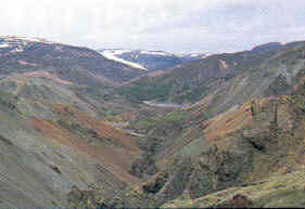
Up from Lón, east of Vatnajökull is a mountain range, valleys and wilderness called Stafafellsfjöll. They are very diverse, both in shape and colour, intercut with canyons and ravines. The nature is especially colourful, and rhyolite, mineral deposits and beautiful stones are common. There are grassy spots in many places, and it’s not unusual to see reindeer on your travels through the wilderness. The Stafafell land is an amazing hiking area for those who love beautiful geological formations.
STAFAFELLSFJÖLL
Stafafell has been the biggest land in Lón for centuries. It was once the location of the province’s main Catholic church and priest until 1920. Numerous smallholdings belonged to the grounds, and the farm Brekka was built up from one of them. Homelands and common grazing grounds in Stafafellsfjöll are the undivided property of these farms. The land above the Stafafell farm is called Heimafjall between Jökulsá and Hlíðará down to Hvannagil and Fláatindur. Inside of Hvannagil are Austurskógar that reach to Sviptungnavarp by Hnappadalstindur. Imposing canyons there block the way for humans and animals. As a whole, this area is called Framfjöll to separate it from Innfjöll, which is to the west of Jökulsá from Skyndidalsá north to the watershed at Hraunar. Víðidalur also belongs to Innfjöll.
Points of Interest
LÓNSÖRÆFI NATURE RESERVE
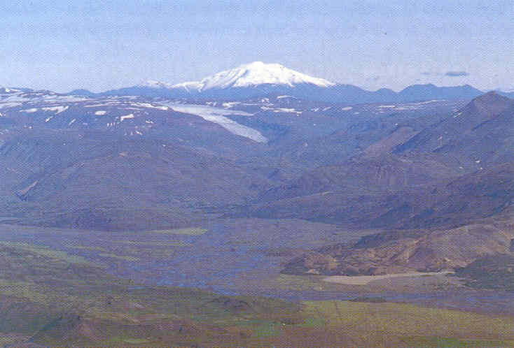
The Lónsöræfi nature reserve is one of the biggest protected areas in Iceland, covering an area of approx. 320 km2. It is an outstanding area and the equivalent of a national park. High mountain ranges, over 1000 metres in places, frame the nature reserve on three sides, crowned with snow and glaciers with surge glacier outlets. Grendill, to the west, is the highest (1570 m) and Jökulsgiltindar (1313 m) to the east, but between them is Sauðhamarstindur (1319 m), close to the middle of the nature reserve. In many places, you can see over to Snæfell (1833 m) beyond Hraun in the north-west.
GEOLOGICAL FORMATIONS AND ECOSYSTEMS
Diverse and colourful geological formations are characteristic of the area. They are mainly 5–7 million years old, but the youngest were created during the ice age. Within the nature reserve and its surroundings are the remains of many central volcanoes, such as Lónseldstöðvar closest to the settlement, Kollumúlaeldstöðvar in the heart of the nature reserve, Flugustaðaeldstöðvar on the eastern border and Eyjabakkaeldstöðvar to the north-west. They can all be identified by acid rock formations, rhyolite and intrusions, in addition to which geothermal heat has played a part in the transformation and rich colour palette of the rock in the area. Its last remains can now be found in mineral springs. A caldera of approx. 35 km2 formed in Kollamúlaeldstöð, and the high volume of breccia north of Illikambur is a sign of an explosive eruption in it.
The incredible erosive powers of the ice age have scoured the land and given it the majestic appearance it has today. Thus, glaciers have carved out Jökulsárdalur and Víðidalur, and the river then improved on the design by adding imposing ravines. Several waterfalls adorn the area: waterfalls in Jökuslá in the innermost part of Vesturdalur, a beautiful and high waterfall in the river that falls south of Vatnadæld and a very high waterfall from Suðurfjall opposite Tröllakrókur; in Víðidalsá, there are waterfalls such as Dynjandi and Beljandi.
Birch scrub is found in many places along Jökulsá; the one in Leiðartungur is the most extensive, as is the one south of Kollumúli, where some ash trees also grow. Mountain plants such as icecup and Arctic poppy follow landslides down into the lowlands, and yellow mountain saxifrage is a reminder of the peculiarities of the Eastfjords’ flora.
There are sources on reindeer in Víðidalur and its vicinity in the 19th century, and many reindeer have been spotted there since 1964.
SETTLEMENT AND FARMING PRACTICES
Two abandoned farms, Eskifell and Grund in Víðidalur, connect the nature reserve to the settlement history and fantastical life in the 19th century. Eskifell was inhabited 1836–1863, and Grund was inhabited three times during the period from 1835 to 1897, around 20 years in total. Around the turn of the century, 1,900 farmers in Stafafell started herding sheep, mostly neutered sheep and orphaned lambs, to the north of Skyndidalsá, and many place names in Lambatungur are a testament to ancient farming practices. Later, sheep were herded to Innfjöll for lambing season and sheared and marked there. This herding from Stafafellstorfa ceased after 1960, after which the area was mostly free of sheep for a decade and the vegetation transformed. Farmers from Nes are thought to have herded sheep to Innfjöll from 1971, and the vegetation in the area shows signs of grazing in many places.
ANCIENT MOUNTAIN ROAD AND TOURISM
In earlier centuries, a mountain road ran through this area along the eastern edge of Vatnajökull, and people rode there between parts of the country, including from North Iceland on their way to fishing grounds south of the glacier. Ancient cairns and place names like Norðlingavað in Jökulsá and Víðidalsá are a testament to this. With the advent of settlement in Víðidalur in the late 19th century, focus turned again to these wilderness areas and several people made their way through them between Fljótsdalur and Lón, including Þovaldur Thoroddsen, the first naturalist. The path ran then, as now, through Illikambur. Farmers in Víðidalur established a pulley bridge over Jökulsá and Víðidalsá in 1892–93. In 1953, Lón residents built a footbridge in Jökulsá by the Nes shepherds’ hut, which farmers in Víðidalur called Stórahnausnes. From the mid-seventies, tourists began to make their way along the path into Illikambur and camped under the ridge. The Austur-Skaftafell’s Travel Association built Múlaskáli (Múla Hut) in Nes in 1991–92, and a year later, the Fljótsdalshérað Travel Association built a lodge by Kollumúlavatn at an elevation of around 630 m. Before that, the lodge near Geldingafell had been built. Together, these lodges form suitable rest stops on the hiking trail between Stafafell and Snæfell or Fljótsdalur. Building a footbridge over Jökulsá in Austurskógar is being considered, as are nearby rest stops, which would connect a continuous hiking trail with lodges between settlements.
Access
All general rules on nature conservation areas apply to the nature reserve. Off-road driving to Illikambur is prohibited, and the area is, in other respects, a hiking area. The Lónsöræfi nature reserve is managed by Vatnajökull National Park, and surveillance and other operations are handled by their staff.
There is a Land Ranger in Múlaskáli in summer who provides information on hiking trails. There is a comparable service in Snæfellsskáli. Information on the area can also be obtained from the Stafafell tourism services.
Hiking Trails
1. ESKIFELL – KAMBAR – ILLIKAMBUR
Old sheep trails run from the abandoned farm Eskifell into Kambar to Illikambur along the imposing canyon of Jökulsá. This trail runs much lower than the vehicle road over Kjarrdalsheiði.
2. MÚLASKÁLI – KOLLUMÚLAVATN – GELDINGAFELL
Hike alongside Jökulsá into Leiðartungur up to Sandar to the lodge by Kollumúlavatn. From there, hike through Tröllakrókahnaus (809 m) north over Kollumúlahraun and through Vatnsdæld to the lodge north of Geldingafell. From there, the trail runs over Eyjabakkajökull to Snæfell, but hiking over Múlahraun to Eyjabakkar and following Jökulsá down to Fljótsdalur is also possible.
3. MÚLASKÁLI – KOLLUMÚLAVATN – MÚLADALUR/GEITHELLNADALUR
Hike into Leiðartungur up to Sandar to Kollumúlavatn and from there to Kollumúlaheiði, over Víðidalsá by Norðlingavað and further to Hnútuvatn through Háás down to Múladalur, where there is a small tourism school by Leirás. A jeep path runs through the valley, some 20 km to the settlement. The same valley is called Geithellnadalur east of the river.
4. VÍÐIDALSGRÖG – SÁUÐÁRVATN – SUÐURDALUR IN FLJÓTSHLÍÐ
Hike from Norðlingavað in Víðidalsá to Víðidalsdrög east of the river and following old cairns over the county border in Víðidalsvarp. The cairned trail runs just west of Sauðárvatn, and from there, people used to ride through Þorgerðarstaðadalur down to Suðurdalur in Fljótsdalur. The shortest hiking trail to the settlement, however, runs east of Sauðárvatn and out to Kiðufell (Suðurfell) and down from the mountain outside of Ófæruá and over Fellsá on the footbridge by the farm Sturluflöt.
5. GJÖGUR – MEINGIL – STÓRIHNAUS
A marked trail runs from Múlaskáli through Gjögur to Meingil and up to the west of the canyon to two waterfalls. From there, it runs above Stórihnaus and down the landslides by Stórahnausgil to the lodge. The road through Gjögur is unstable in parts and troublesome for those with a fear of heights.
6. MÚLAKOLLUR
In Múlakollur (901 m), it’s possible to hike from the trail through Gjögur or almost straight up from Múlaskáli. A longer trail runs through Leiðartungur and from Sandar south-east to Múlakollur. From its edges, a little to the south, you can see Sviptungnakollur, Hnappadalstindur and Grísatungnagil east of Víðidalsá. On the way back, you can go down between ravines.
7. GRUND IN VÍÐIDALUR
To get to Víðidalur, you will need to go through Leiðartungur and east over Sandar. The Grund farm sits in a hollow at an elevation of approx. 400 m east of Víðidalsá under the slopes of Hofsjökull. From there, there is a clear view of the remains of the last settlement in 1883. 97. There no bridge over Víðidalsá, and the river can be difficult to wade or cross, but it can sometimes be traversed via a snowbank further north in the ravine. From Grund, a hiking trail runs through a pass south of Hofsjökull to Hofsdalur or Flugustaðadalur in Álftafjörður.
8. JÖKULSÁRDALUR – TRÖLLAKRÓKAR – VESTURDALUR
An entertaining but difficult day hike is into Jökulsárdalur through Stórsteinar and Tröllakrókar into Vesturdalur. It is sensible not to follow Jökulsá between Leiðartungur and Stórsteinar due to a landslide barrier by a section of the river. It is possible to reach the inner part of Kollamúli through landslides inside of Tröllakrókar and hike to the edge of the protuberance and through Leiðartungur on the way back.
9. SAUÐHAMARSTINDUR
Hiking on Sauðhamarstindur (1319 m) involves climbing, and it is better to bring cleats and an ice axe. You can hike through Víðibakkasker or along a canyon south of Múlaskáli. You will have to climb a landslide up a high rock belt and through snowbanks on Röðull, which forms the south-eastern shoulder of the mountain, and from there to the highest peak. The Land Ranger will provide further guidance.
10. SKYNDIDALUR – KEILUVELLIR – HOFFELLSDALUR
From Jökulsársandur is a comfortable hike into the northern side of Skyndidalur to Keiluvellir. Within it, Lambatungnaá merges forcefully with Skyndidalsá. You can hike over Lambatungnajökull or wade over Skyndidalsá and up Nautastígur and through the nesting grounds to the south in Hoffellsdalur.