

- Visiting Iceland
- Travel Information
- FAQ
- Protected Areas
- Westfjords
- Breidafjordur
- Dynjandi in Arnarfjordur
- About the area
- Access and services
- Nature
- Culture and history
- Drone use at Dynjandi
 Dynjandi in Arnarfjordur
 - Flatey in Breidafjordur
- Hornstrandir
- Hrisey, Reykholahreppur
- Surtarbrandsgil
- Vatnsfjordur
Westfjords - North West
- North East
- Boggvistadafjall
- Dettifoss and a row of waterfalls
- Dimmuborgir
- Public park in Glerardalur
- Reservation in Svarfadardalur
- Godafoss in Thingeyjarsveit
- Hraun in Oxnadalur
- Hverastrytur in Eyjafjordur
- Hverfjall
- Krossanesborgir
- Myvatn and Laxa
- Seljahjallagil
- Skutustadagigar
- Vatnajokull National Park
- Vestmannsvatn
North East - West
- Andakill
- Bardarlaug, Snaefellsbaer
- Blautos and Innstavogsnes
- Breidafjordur
- Budahraun
- Einkunnir, Borgarbyggd
- Eldborg in Hnappadalur
- Geitland, Borgarbyggd
- Grabrokargigar, Borgarbyggd
- Grunnafjordur
- Hraunfossar, Borgarbyggd
- Husafellsskogur, Borgarbyggd
- Kalmanshellir
- Melrakkaey
- Stedji (Staupasteinn)
- The coast by Stapi and Hellnir
- Vatnshornsskogur, Skorradalur
- Snaefellsjokull National Park
West - Search by name
- East
- South West
- Akurey
- Alafoss, Mosfellsbaer
- Astjorn, Hafnarfjordur
- Astjorn and Asfjall, Hafnarfjordur
- Bakkatjorn, Seltjarnarnes
- Blafjoll Public Park
- Borgir, Kopavogur
- Bringur, Mosfellsdalur
- Burfell, Gardabaer
- Eldborg in Blafjoll
- Eldborg in Geitahlid
- Eldey, Reykjanesbaer
- The shore by Kasthusatjorn
- Fossvogsbakkar, Reykjavik
- Gardahraun, Gardabaer
- Galgahraun, Gardabaer
- Grotta, Seltjarnarnes
- Hamarinn, Hafnarfjordur
- Haubakkar, Reykjavik
- Hleinar, Hafnarfjordur
- Hlid, Alftanes
- Hvaleyrarlon and Hvaleyrarhofdi
- Kaldarhraun and Gjarnar
- Kasthusatjorn, Alftanes
- Laugaras, Reykjavik
- Litluborgir, Hafnarfjordur
- Raudholar, Reykjavik
- Reykjanes Public Park
- Skerjafjordur, Gardabaer
- Skerjafjordur, Kopavogur
- Stekkjarhraun, Hafnarfjordur
- Trollaborn, Lækjarbotnar
- Tungufoss, Mosfellsbaer
- Valhusahaed, Seltjarnarnes
- Varmarosar, Mosfellsbaer
- Vifilsstadavatn, Gardabaer
- Vigholar, Kopavogur
South West - South
- Alftaversgigar
- Arnahellir in Leitahraun
- Dverghamrar
- Dyrholaey
- Fjallabak Nature Reserve
- Geysir Area
- Gullfoss
- Herdisarvik
- Jorundur in Lambahraun
- Kerlingarfjoll
- Kirkjugolf
- Oddaflod
- Pollengi and Tunguey
- Skogafoss
- Surtsey
- Area in Thjorsardalur
- Vatnajokull National Park
- Videy in Thjorsa
- Thingvellir National Park
- Thjorsarver
South - Mývatn and Laxá
- National Parks
Protected Areas - Westfjords
- Permits in protected areas
- Operational licence
- Photography, cinematography and drone flying
- Research permit
Permits in protected areas - Drones in protected areas
- Guidelines for using drones in protected areas
- Flights in protected areas
- Apply for permit
Drones in protected areas - Volunteers
- Snæfellsjökull National Park
Visiting Iceland - Wildlife
- Air & Climate
- Ocean & Water
- Industry
- Chemicals
- Frequently asked questions
- Biocides
- Classification and labelling – CLP
- Cosmetics
- Detergents
- Fluorinated greenhouse gases (F-gases)
- Fuel
- Supervision, inspection and coercive measures
- Certificate for pest control
- Plant protection products
- POPs
- Certificate for professional use of plant protection products
- REACH
Frequently asked questions - Biocides
- Classification and labelling
- CLP
- Classification
- Labelling
- Packaging and retention
Classification and labelling - Cosmetics
- Detergents
- F-gases
- Fuel
- Plant protection products
- Authorisation
- Harmonised Risk Indicators
Plant protection products - POPs
- REACH
- Fees
Chemicals - Frequently asked questions
- Importation of Alien Species
- ETS
Industry - Chemicals
- Circular Economy
- Waste
- Waste Management
Circular Economy - The Agency
.svg)
Alftaversgigar
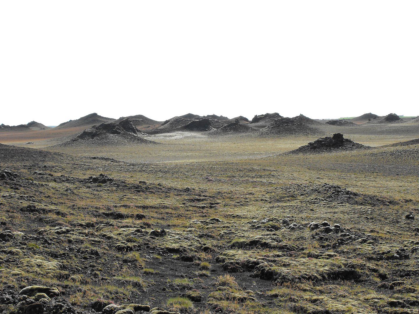
Álftaver is bordered by Kúðafljót to the east and Blautakvísl to the west. The province is named after the lush wetlands that characterize the area. The name Álftaver also suggests that the area was much visited by swans. Swans seek out ponds and wetlands in summer and nest on the banks, on islets or in marshes.
Álftaversgígar is a protected natural monument that was formed in the Eldgjá eruption in 934. The volcanic activity in the Eldgjá eruption was massive, and lava gushed up and flowed from a 75 km long fissure that opened up between Mýrdalsjökull and Vatnajökull. It is believed that the eruption lasted for 3 to 8 years and was accompanied by a massive lava flow, ash and a large glacial outburst. The Eldgjá lava flowed approx. 70 km towards the ocean in several lava streams. The largest flows are called Álftavershraun, Meðallandshraun and Landbrotshraun.
The Formation of Pseudo Craters
West of the settlement in Álftaver are clusters of pseudo craters that have largely protected the settlement from glacial outbursts from Katla. It has been proven that Álftaversgígar formed in the Eldgjá eruption in 934 to 940 when lava flowed over wetlands. Pseudo craters are formed when hot magma comes into direct contact with water-soaked substrates and causes the water to instantly boil. Magma flows through lava tubes, but where the magma bursts from the lava tubes, lava nuggets are formed. These lava nuggets bulge out due to magma flow into them, but gradually the flow is limited to fixed lava pipes inside the semi-solidified lava. When the lava nuggets bulge out, their weight increases and the lava sinks into the substrate until the bottom crust breaks beneath the lava channel. This causes magma to flow directly into the water-soaked substrate, causing steam explosions that form pseudo craters on the surface. The explosive activity prevents further lava flows along the lava channel below the steam explosions, leading to a shift in the lava flow and the formation of new lava channels and new pseudo craters. This chain-reaction goes on until the lava has worked its way over the wetland and built up a cluster of pseudo craters.
Sources:
Júlíus Sólnes, Freysteinn Sigmundsson, & Bjarni Bessason. (2013). Natural Disasters in Iceland: Volcanic Eruptions and Earthquakes.
Guðrún Larsen (2000). Holocene eruptions within the Katla volcanic system, south Iceland: Characteristics and environmental impact. Glacier 49, 1–28.
The natural monument covers an area of 3,436.1 ha.